Solutions for Enhanced Maritime Domain Awareness
Maritime Domain Awareness is a complex challenge: requiring security and safety on trade routes, detection of illegal activities and protection of people and the environment.

Supporting you in Mitigating Risks
Effective maritime surveillance requires scalable and flexible tools to ensure full coverage - from territorial waters to the Exclusive Economic Zone (EEZ) and the High Seas.
With over 30 years experience providing maritime surveillance from both coastlines and space, our integrated systems and services deliver a reliable situational picture, enabling efficient decision-making when action is needed.
Airbus supports you at every stage of operations, whether preventing risks, analysing situations real time to enable informed decisions or conducting post-event analysis to gather evidence and enhance future processes.


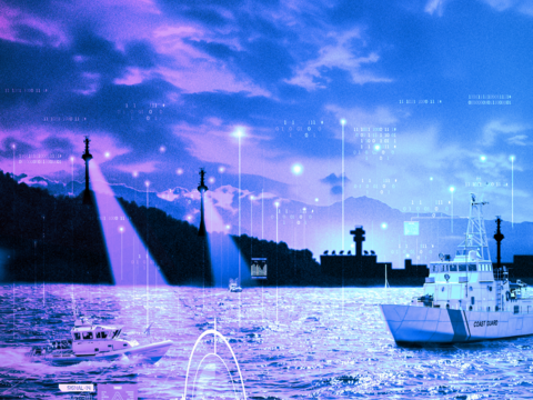
Representation of maritime surveillance with a control tower and its sensors, satellite imagery
Detection, Recognition and Identification
Regular monitoring, whether from the coastlines with STYRIS ® or from space via our satellite sensors; enhances threat validation alongside patrol vessels and aircraft, optimizing the use of these traditional means.
Our solutions combine databases, AI analytics and Airbus expertise to identify potential risks and provide actionable intelligence to support informed decision making.


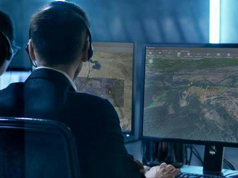
Maritime operator monitoring the maritime situation through the STYRIS on his monitors
Real-time Monitoring for Rapid Response
Access to a real-time maritime picture enables swift action against identified threats before risks escalate. It also enhances resource efficiency by providing accurate and up-to-date information for operations such as Search and Rescue.


hand pointing to a digital bubble view with a frigate
Accurate Situational Analysis
Understanding the cause and development of an incident requires collecting data, intelligence and historical records to trace its origins.
Analysis tools like i4D integrate data from STYRIS, satellite sensors and other sources to deliver precise situational assessments.
Documenting incidents is essential for preventing future threats and training operators to respond effectively in similar situations.
For those who monitor our seas
Explore our Maritime Capabilities
Documents
Maritime Domain Awareness brochure
I4D Brochure 2023
STYRIS CSS Brochure
STYRIS VTS Brochure
Documents
Maritime Domain Awareness brochure
I4D Brochure 2023
STYRIS CSS Brochure
STYRIS VTS Brochure
Browse our Solutions
-
STYRIS®, Coastal Surveillance System
A dedicated system for maritime surveillance, reconnaissance and traffic monitoring enhancing maritime situational awareness.
-
Imagery and Data
Airbus provides access to its optical and radar sensors, as well as Radio-Frequency (RF) data from HawkEye 360.
-
I4D Intelligence: Geospatial Analysis & Multi-Source Data Fusion
I4D is a GEOINT solution, delivering reliable intelligence for informed tactical decisions reports for mission preparation.
-
Smart Solutions for Maritime Surveillance
Airbus solutions offer unique maritime intelligence, enhancing surveillance capabilities from coastal areas to the open seas.


Keep up to date with our latest news
In the Spotlight


